Saturday, June 30, 2012

Yosemite National Park - Nearby Sites - Deviles Postpile


Deviles Postpile National Monument


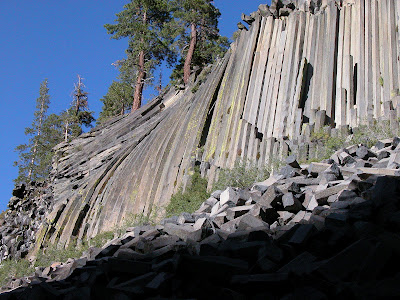
50 miles from Yosemite's Tioga Pass Entrance, Devils Postpile National Monument established in 1911 by presidential proclamation, Devils Postpile National Monument protects and preserves the Devils Postpile formation, the 101-foot high Rainbow Falls, and pristine mountain scenery.  The formation is a rare sight in the geologic world and ranks as one of the world's finest examples of columnar basalt. Its columns tower 60 feet high and display an unusual symmetry.

To visit, park your car  at the Mammoth Mountain Ski Area and use the mandatory shuttle. The shuttle bus operates from mid-June through the Wednesday after Labor Day.
http://www.nps.gov/depo/planyourvisit/loader.cfm?csModule=security/getfile&PageID=142763


Deviles Postpile
Deviles Postpile

Deviles Postpile
Deviles Postpile

Deviles Postpile - Reds Creek

Deviles Postpile - Sot Cher Lake

Deviles Postpile - Soda Spring Meadow


Yosemite National Park - Nearby Sites - Mono Lake


Mono Lake 

Mono Lake Area Map

Mono Lake Area Map

 
Just 13 miles away from Tioga Pass entrance of Yosemite, Mono Lake is one of the oldest lakes in the western hemisphere. Mono Lake is hauntingly beautiful, reflecting the snow-capped Sierra Nevada in its shimmering blue waters. An immense inland sea, the 70 square-mile lake fills a natural basin, 700 square-miles in size. Together with nearby volcanoes, ghost towns and trout-filled streams, this area is a natural wonderland for the entire family. Click here for more details.


Mono Lake Tufa


http://www.flickr.com/photos/hdvesely/7169485835/sizes/z/in/pool-22002219@N00/


Yosemite National Park Maps


Yosemite National Park Maps


There are four entrances into Yosemite park,

  • highway 120 east through Manteca to Big Oak Flat entrance
  • highway 140 east through Merced to  Arch Rock entrance
  • highway 41 north through Fresno to  South entrance
  • highway 120 west through Mono Lake to Tioga Pass entrance

Three most visited areas,


Yosemite Valley and Glacier Point Area Map

Yosemite Valley and Glacier Point Area Map


Tuolumne Meadows Visitor Center Area Map

Tuolumne Meadows Visitor Center Area Map


Wawona Information Station Area Map

Wawona Information Station Area Map


Friday, June 29, 2012

Olympic National Park Pictures


Olympic National Park Pictures


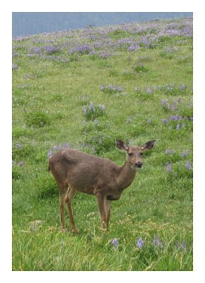
Hurricane Ridge Deer

Hurricane Ridge Deer


Hurricane Ridge Deer

Hurricane Ridge Deer

Hurricane Ridge Deer

Hurricane Ridge Deer


Crescent Lake

Crescent Lake


Hurricane Ridge Flower

Hurricane Ridge Flower


Crescent Lake

Crescent Lake


Lower Lena Lake

Lower Lena Lake


oysters at Hood Canal

Oysters at Hood Canal


Sea Star at Hood Canal

Sea Star at Hood Canal


Olympic National Park Maps


Olympic National Park Maps


You can find Olympic National Park map from nps.gov website. But it is quite big, you can be overwhelmed by it. Again, I divided the map into three regions: the pacific coastline, the mountains, and the rain forest.

Pacific Coastline


Ozette Lake Map - Olympic NP

Ozette Lake Area Map


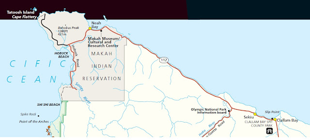
Cape Flattery Map - Olympic NP

Cape Flattery Area Map


Mora Area Map - Olympic NP

Mora Area Map


 Mountain Region


Hurricane Ridge Map - Olympic NP

Hurricane Ridge Area Map


Rain Forest Maps


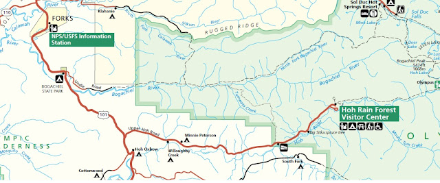
Hoh Rain Forest Map - Olympic NP

Hoh Rain Forest Area Map


Quinault Rain Forest Map - Olympic NP

Quinault Rain Forest Area Map


Olympic National Park

Olympic National Park Map


Olympic National Park 


It is located in the U.S. state of Washington, in the Olympic Peninsula. The park can be divided into three basic regions: the pacific coastline, glaciated mountains, and the rain forest. Area: 1,442 sq miles (3,733 km²) Address: 3002 Mount Angeles Road, Port Angeles, Washington 98362 Phone: (360) 565-3130

Pacific Coastline


The coastal portion of the park is a rugged, sandy beach along with a strip of adjacent forest. It is 73 miles (117 km) long but just a few miles wide. The most popular piece of the coastal strip is the 9-mile (14 km) Ozette Loop.
Cape Flattery

La Push
Shi Shi Beach
La Push
La Push

Rain Forest


The western side of the park is mantled by a temperate rain forest, which receives annual precipitation of about 150 inches (380 cm), making this perhaps the wettest area in the continental United States (the island of Kauai in the state of Hawaii gets more rain).
Rain Forest - Hall of Moss Trial

Rain Forest - Hall of Moss Trial

Glaciated Mountains


Within the center of Olympic National Park rise the Olympic Mountains whose sides and ridgelines are topped with massive, ancient glaciers. The mountains themselves are products of accretionary wedge uplifting related to the Juan De Fuca Plate subduction zone. The geologic composition is a curious mélange of basaltic and oceanic sedimentary rock. The western half of the range is dominated by the peak of Mount Olympus, which rises to 7,965 feet (2,428 m).
Hurricane Ridge
Hurricane Ridge

Sunday, June 10, 2012

國家公園的定義


國家公園的定義是什麼?

國家公園是一種保留區,通常由政府所擁有,目的是保護某地不受人類發展和污染的傷害。
世界上最早的“国家公园”为1872年美国建立“黄石国家公园”,之后“国家公园”一词为世界很多国家使用;
黄石公园
美國一共有58座國家公園,由美國內政部下轄的美國國家公園管理局負責管理。
東北格陵蘭國家公園
世界上最大的國家公園是東北格陵蘭國家公園 Northeast Greenland National Park,它成立於1974年。


據世界自然保護聯盟 IUCN(國際自然及自然資源保護聯盟 the International Union for Conservation of Nature),2006年,全世界的國家公園有6,555个


Yosemite (优山美地)National Park
世界上最美麗的國家公園有,
  • Yosemite National Park, United States
  • Fuji-Hakone-Izu National Park, Japan
  • Grand Canyon National Park, United States
  • Guilin and Lijiang River National Park, China
  • Banff National Park, Canada
  • Parque National Torres del Paine, Chile
  • Fiordland National Park, New Zealand
  • Kakadu National Park, Australia
  • ...


What is the Definition of National Park?


What is the Definition of National Park?


National Park  is a reserve of natural, semi-natural, or developed land that a sovereign state declares or owns. 


Which One is the First National Park in US?


The world's first "national park" is America's Yellowstone National Park which established in 1872, since then, the term "National Park" has been used by many countries in the world. 

How Many National Parks in US?


The United States has 58 protected areas known as national parks, which are operated by the National Park Service, an agency of the Department of the Interior


Which One is the Largest National Park in the World? 

The largest national park in the world is the Northeast Greenland National Park, which was established in 1974. 


According to the IUCN (the International Union for Conservation of Nature), there were 6,555 national parks worldwide in 2006. 


The World Most Beautiful National Parks

  • Yosemite National Park, United States
  • Fuji-Hakone-Izu National Park, Japan
  • Grand Canyon National Park, United States
  • Guilin and Lijiang River National Park, China
  • Banff National Park, Canada
  • Parque National Torres del Paine, Chile
  • Fiordland National Park, New Zealand
  • Kakadu National Park, Australia
  • ...


Friday, June 8, 2012

Yosemite Park - Half Dome Permit - 爬山許可證


Yosemite Half Dome Permit 爬山許可證 


爬Half Dome的顶部必須事先申请許可證。這是一項臨時措施,以解決 Half Dome 頂徑沿線擁擠和安全。

每一天將允許最多400 旅行者 (300天徒步旅行者和100背包旅行者)上 Half Dome 超越 subdome 的路径。

今年,許可證將通過抽籤中彩票的形式,每天发放 50张許可證,如果想得到週六爬山許可證,您可在週四午夜至下午1時太平洋時間申请, 週四晚上会收到一封電子郵件通知。結果也可在第二天早上網上或通過電話得知。

申請許可證,要上 Recreation.gov 网站或致電877/444-6777(呼叫中心的開放時間為上午7至晚上9時(太平洋時間)。

收費分两次进行。
  第一次收費,這是在你提交申請的時間, 在線 $ 4.50 通過電話 $ 6.50。
  第二次收費,只有當你收到許可證,每人5元。


Half Dome Cable