Sunday, July 22, 2012

WEEKEND GETAWAY IDEAS - Moss Landing - CA


WEEKEND GETAWAY IDEAS - from Bay Area

 Moss Landing, CA


Moss Landing locates in Monterey County, California, 50 miles of San Jose, 20 miles south of Santa Cruz.  It is a great place for a day trip for Bay Area family. 

Moss Landing is the pathway to state and federal protected lands, including Moss Landing State Beach, Moss Landing Wildlife Area, and Elkhorn Slough National Estuarine Research Reserve. 

Driving Direction From San Jose


Driving Direction from San Jose to Moss Landing

Santa Cruz to Moss Landing Map


Santa Cruz to Moss Landing Map


First Stop: Moss Landing State Beach


Moss Landing State Beach Map


From highway 1, when you see the sign "Moss Landing State Beach", exit out on your right side. Following the sign to the parking area. Walking along the Jetty road, you should see a group of sea utters floating in the water, sea lions resting on the shore, and people kayaking. 


This Sea Utter is a very active one


This one is comfortably floating on the water.


You can spot some other wild animals here. 


We found some live Jelly fishes floating with seaweed.


Second Stop: North Harbor of Moss Landing


Driving back to Highway 1, exit on your right. The north harbor is the home of Elkhorn Yacht Club, Monterey Bay Kayaks, and Sea Harvest Fish Market & Restaurants.

You can launch your own kayak here or rent it at Monterey Bay Kayaks

Kayaking at Moss Landing Harbor

Walk or park your car near the Sea Harvest Fish Market & Restaurants. Mass of sea lions almost on your feet. 

Sea Lion fighting for the his space at Moss Landing Harbor
Sea Lion fighting for his space at Moss Landing Harbor

Third Stop: Elkhorn Slough National Estuarine Research Reserve


Elkhorn Slough National Estuarine Research Reserve The 1700-acre Reserve is a hub of activity and hosts programs that promote education, research, and conservation in Elkhorn Slough. There are five miles of trails that meander through beautiful oak woodlands, calm tidal creeks, and freshwater marshes. The visitor center offers tours on the weekends and special events throughout the year.

Address and Map to The Visitor Center

1700 Elkhorn Road
Watsonville, CA 95076
Telephone: (831) 728-2822

A couple walking on South Loop Trial


You can also Kayak from Harbor to Here

Lunch Stop: Phil's Fish Market & Eatery


Phil's Fish Market & Eatery
7600 Sandholdt Road, Moss Landing, CA 95039


Thanks for visiting my blog, enjoy your day trip at Moss Landing. 


Tuesday, July 10, 2012

Weekend Getaway Ideas - Getty Center - LA


Weekend Getaway Ideas 周末好去处 - Getty Center - LA


Address
1200 Getty Center Drive
Los Angeles, California 90049
Admission Is Free
Admission to the Getty Center and to all exhibitions is FREE; Parking is $15


Opening Hours

Monday
CLOSED
Tuesday
10:00 a.m.–5:30 p.m.
Wednesday
10:00 a.m.–5:30 p.m.
Thursday
10:00 a.m.–5:30 p.m.
Friday
10:00 a.m.–9:00 p.m.
Saturday
10:00 a.m.–9:00 p.m.
Sunday
10:00 a.m.–5:30 p.m.

Closed Mondays and on January 1, July 4 (Independence Day), Thanksgiving, and December 25 (Christmas Day).


Getty Center  - LA

Getty Center  - LA

Getty Center  - LA

Weekend Getaway Ideas - Huntington Library, Art, Gardens


Weekend Getaway Ideas 周末好去处

Huntington Library, Art Collections, and Botanical Gardens


Address: 1151 Oxford Road, San Marino, CA 91108
Parking: free
Hours:
Monday 10:30 a.m. to 4:30 p.m.
Tuesday Closed
Wednesday 10:30 a.m. to 4:30 p.m.
Thursday 10:30 a.m. to 4:30 p.m.
Friday 10:30 a.m. to 4:30 p.m.
Saturday 10:30 a.m. to 4:30 p.m.
Sunday 10:30 a.m. to 4:30 p.m.

The Huntington is closed on Thanksgiving, Christmas Eve, Christmas Day, New Year’s Day, and Independence Day.


Local Map - http://www.huntington.org/uploadedFiles/Files/PDFs/direcs_local.pdf

Map of Ground - http://www.huntington.org/uploadedFiles/Content/Visit/groundsmap.pdf


The Huntington Botanical Gardens


Covers 207 acres, of which approximately 120 are landscaped and open to visitors. More than 14,000 different varieties of plants are showcased in more than a dozen principal garden areas. Forty gardeners, a curatorial staff of seven, and more than 100 volunteers maintain the botanical collections.


  • Desert Garden
  • Chinese Garden
  • Japanese Garden
  • Jungle Garden
  • Lily Ponds
  • Rose Garden
  • Australian Garden
  • Camellia Garden
  • Children’s Garden
  • Herb Garden
  • Palm Garden
  • Shakespeare Garden
  • Subtropical Garden


Japanese Garden

Completed in 1912, the nine-acre site, with its picture-postcard views of koi-filled ponds, distinctive moon bridge, and historic Japanese House, has attracted more than 20 million visitors since the institution opened to the public in 1928.


Desert Garden

One of the largest and oldest assemblages of cacti and other succulents in the world. The desert garden features more than 5,000 species of succulents and desert plants in sixty landscaped beds.
Nearly 100 years old, it has grown from a small area on the Raymond fault scarp when in 1907-1908 William Hertrich brought in plants from local nurseries, private residences, public parks, and from collection trips to the Southwest and Mexican deserts. Today the two dozen families of succulents and other arid adapted plants have developed into a 10-acre garden display, the Huntington’s most important conservation collection, a most important mission and challenge.


Lily Ponds

The first garden established in 1904 by William Hertrich had natural springs that emerged from rocks on the Raymond Hill Fault. The solution to an unsightly gully in the southeast corner of the gardens, the four acres that make up the lily ponds were a perfect place to build two large and three small ponds. The pond water, which is circulated and recycled, is home to turtles, bullfrogs, Japanese koi, aquatic plants, and an occasional mallard family.


Chinese Garden

Inspired by the centuries-old Chinese tradition of private gardens designed for scholarly pursuits, Liu Fang Yuan, or the Garden of Flowing Fragrance, combines the scenic beauty of nature with the expressiveness of literature to give deeper meaning to the landscape. A walk through its paths enriches the mind and spirit alike. The Huntington—with its renowned collections of art, rare books, manuscripts, and plants—was founded on this same philosophy by Henry E. Huntington in 1919.


Rose Garden

The three and a half acre rose garden was designed by Myron Hunt and first planted by William Hertrich as a display garden in 1908. In the 1970s, the garden was reorganized as a “collection garden” with more than 1,200 cultivars (approx 4,000 individual plants) arranged historically to trace the development of roses from ancient to modern times beginning with the Egyptians, Greeks, and Romans.  

Saturday, June 30, 2012

Yosemite National Park - Nearby Sites - Deviles Postpile


Deviles Postpile National Monument


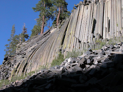
50 miles from Yosemite's Tioga Pass Entrance, Devils Postpile National Monument established in 1911 by presidential proclamation, Devils Postpile National Monument protects and preserves the Devils Postpile formation, the 101-foot high Rainbow Falls, and pristine mountain scenery.  The formation is a rare sight in the geologic world and ranks as one of the world's finest examples of columnar basalt. Its columns tower 60 feet high and display an unusual symmetry.

To visit, park your car  at the Mammoth Mountain Ski Area and use the mandatory shuttle. The shuttle bus operates from mid-June through the Wednesday after Labor Day.
http://www.nps.gov/depo/planyourvisit/loader.cfm?csModule=security/getfile&PageID=142763


Deviles Postpile
Deviles Postpile

Deviles Postpile
Deviles Postpile

Deviles Postpile - Reds Creek

Deviles Postpile - Sot Cher Lake

Deviles Postpile - Soda Spring Meadow


Yosemite National Park - Nearby Sites - Mono Lake


Mono Lake 

Mono Lake Area Map

Mono Lake Area Map

 
Just 13 miles away from Tioga Pass entrance of Yosemite, Mono Lake is one of the oldest lakes in the western hemisphere. Mono Lake is hauntingly beautiful, reflecting the snow-capped Sierra Nevada in its shimmering blue waters. An immense inland sea, the 70 square-mile lake fills a natural basin, 700 square-miles in size. Together with nearby volcanoes, ghost towns and trout-filled streams, this area is a natural wonderland for the entire family. Click here for more details.


Mono Lake Tufa


http://www.flickr.com/photos/hdvesely/7169485835/sizes/z/in/pool-22002219@N00/


Yosemite National Park Maps


Yosemite National Park Maps


There are four entrances into Yosemite park,

  • highway 120 east through Manteca to Big Oak Flat entrance
  • highway 140 east through Merced to  Arch Rock entrance
  • highway 41 north through Fresno to  South entrance
  • highway 120 west through Mono Lake to Tioga Pass entrance

Three most visited areas,


Yosemite Valley and Glacier Point Area Map

Yosemite Valley and Glacier Point Area Map


Tuolumne Meadows Visitor Center Area Map

Tuolumne Meadows Visitor Center Area Map


Wawona Information Station Area Map

Wawona Information Station Area Map